DSCRTP (Map Service)
View In: ArcGIS JavaScript ArcGIS.com WMTS
Current Version: 10.81
Service Description:
This is a tile layer providing access to deep-sea coral and sponge data, images, and technical reports from research funded by NOAA’s Deep Sea Coral Research and Technology Program and its partners. Explore this data in the Deep Sea Coral Data Portal (NOAA GeoPlatform entry).
Data Search, Discovery & Download
The DSCRTP map allows for search, discovery, and download of the National Deep Sea Corals and Sponges Database. All points are categorized and colored by common vernacular categories. Users can search by taxon, region, time, and depth. Data downloads can be initiated using the search parameters on the map and the on-screen geographic extent.Information Access
Users can also view site characterization reports for DSCRTP funded research. These reports give habitat summaries of specific undersea areas and summarize the dives on the area.
Deep Sea Coral Database DocumentationDSCRTP's Technical Memo on the National Database. Go to the publication
Metadata for the Deep Sea Coral Database. Go to the metadata
The legend for this layer is displayed below:
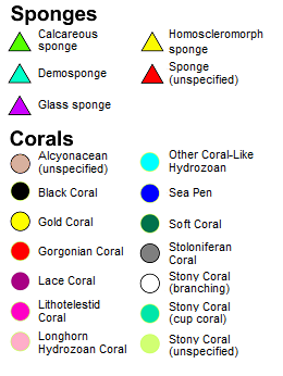
Map Name: Layers
Legend
All Layers and Tables
Layers:
- Locations(0)
This is a tile layer providing access to deep-sea coral and sponge data, images, and technical reports from research funded by NOAA’s Deep Sea Coral Research and Technology Program and its partners. Explore this data in the Deep Sea Coral Data Portal (NOAA GeoPlatform entry).
Data Search, Discovery & Download
The DSCRTP map allows for search, discovery, and download of the National Deep Sea Corals and Sponges Database. All points are categorized and colored by common vernacular categories. Users can search by taxon, region, time, and depth. Data downloads can be initiated using the search parameters on the map and the on-screen geographic extent.Information Access
Users can also view site characterization reports for DSCRTP funded research. These reports give habitat summaries of specific undersea areas and summarize the dives on the area.
Deep Sea Coral Database DocumentationDSCRTP's Technical Memo on the National Database. Go to the publication
Metadata for the Deep Sea Coral Database. Go to the metadata
The legend for this layer is displayed below:
Copyright Text: NOAA National Centers for Environmental Information, National Marine Fisheries Service Office of Habitat Conservation
Spatial Reference:
102100
Single Fused Map Cache: true
Capabilities: Map,TilesOnly,Tilemap
Tile Info:
- Height: 256
- Width: 256
- DPI: 96
- Levels of Detail: (# Levels: 24)
- Level ID: 0 [Start Tile, End Tile]
- Resolution: 156543.033928
Scale: 5.91657527591555E8 - Level ID: 1 [Start Tile, End Tile]
- Resolution: 78271.5169639999
Scale: 2.95828763795777E8 - Level ID: 2 [Start Tile, End Tile]
- Resolution: 39135.7584820001
Scale: 1.47914381897889E8 - Level ID: 3 [Start Tile, End Tile]
- Resolution: 19567.8792409999
Scale: 7.3957190948944E7 - Level ID: 4 [Start Tile, End Tile]
- Resolution: 9783.93962049996
Scale: 3.6978595474472E7 - Level ID: 5 [Start Tile, End Tile]
- Resolution: 4891.96981024998
Scale: 1.8489297737236E7 - Level ID: 6 [Start Tile, End Tile]
- Resolution: 2445.98490512499
Scale: 9244648.868618 - Level ID: 7 [Start Tile, End Tile]
- Resolution: 1222.99245256249
Scale: 4622324.434309 - Level ID: 8 [Start Tile, End Tile]
- Resolution: 611.49622628138
Scale: 2311162.217155 - Level ID: 9 [Start Tile, End Tile]
- Resolution: 305.748113140558
Scale: 1155581.108577 - Level ID: 10 [Start Tile, End Tile]
- Resolution: 152.874056570411
Scale: 577790.554289 - Level ID: 11 [Start Tile, End Tile]
- Resolution: 76.4370282850732
Scale: 288895.277144 - Level ID: 12 [Start Tile, End Tile]
- Resolution: 38.2185141425366
Scale: 144447.638572 - Level ID: 13 [Start Tile, End Tile]
- Resolution: 19.1092570712683
Scale: 72223.819286 - Level ID: 14 [Start Tile, End Tile]
- Resolution: 9.55462853563415
Scale: 36111.909643 - Level ID: 15 [Start Tile, End Tile]
- Resolution: 4.77731426794937
Scale: 18055.954822 - Level ID: 16 [Start Tile, End Tile]
- Resolution: 2.38865713397468
Scale: 9027.977411 - Level ID: 17 [Start Tile, End Tile]
- Resolution: 1.19432856685505
Scale: 4513.988705 - Level ID: 18 [Start Tile, End Tile]
- Resolution: 0.597164283559817
Scale: 2256.994353 - Level ID: 19 [Start Tile, End Tile]
- Resolution: 0.298582141647617
Scale: 1128.497176 - Level ID: 20 [Start Tile, End Tile]
- Resolution: 0.14929107082380833
Scale: 564.248588 - Level ID: 21 [Start Tile, End Tile]
- Resolution: 0.07464553541190416
Scale: 282.124294 - Level ID: 22 [Start Tile, End Tile]
- Resolution: 0.03732276770595208
Scale: 141.062147 - Level ID: 23 [Start Tile, End Tile]
- Resolution: 0.01866138385297604
Scale: 70.5310735 - Format: PNG32
- Compression Quality: 0
- Origin:
- X: -2.0037508342787E7
Y: 2.0037508342787E7
- Spatial Reference:
102100
- XMin: -2.0036951745335277E7
YMin: -1.4878979191773359E7
XMax: 2.003739702329845E7
YMax: 1.2658425230164178E7
Spatial Reference:
102100
- XMin: -2.0036951745335277E7
YMin: -1.4878979191773359E7
XMax: 2.003739702329845E7
YMax: 1.2658425230164178E7
Spatial Reference:
102100
Max Scale: 0.0
Min LOD: 0
Max LOD: 10
Units: esriMeters
Supported Image Format Types: PNG32
Export Tiles Allowed: false
Max Export Tiles Count: 100000
Resampling: true
Document Info:
- Title: Deep-Sea Corals
- Author: ncei_noaa
- Comments:
- Subject: A tile layer which provides access to deep-sea coral and sponge data, images, and technical reports from research funded by NOAA’s Deep Sea Coral Research and Technology Program and its partners.
- Category:
- Keywords: DSCRTP, deep-sea corals, NOAA, NCEI, corals